Microdrones and GE Launch the GE Industrial Drone Line

July 7, 2021 Rome, NY- GE and Microdrones have entered into a worldwide licensing partnership, where Microdrones will bring the GE industrial drone line to market globally, providing professionals access to powerful aerial surveying technology that will enable them to work more efficiently, accurately, safely and profitably.
The GE industrial drone line brings together two industrial companies which highly complement one another. GE enters the professional UAV market, a natural extension of its current activities, by working with Microdrones, the industry leader in professional drone survey equipment. As for Microdrones, it has a unique opportunity to benefit from GE’s industrial market expertise, global reach and experience scaling up industrial businesses.
Together, they unite in releasing the GE industrial drone line. The strategy will accelerate deployment of Microdrones survey equipment as an essential tool for the creation and maintenance of digital twins, digital terrain models, maps and other geospatial products. These systems are sought after by professionals in land surveying, construction, precision agriculture, mining, power line inspection, forestry management and more.
The GE industrial drone line is manufactured at the Microdrones facility in Siegen, Germany; systems will be sold and supported across six continents. All products that are part of the GE industrial drone line are equipped with improvements in flight efficiency, as well as enhanced safety features.
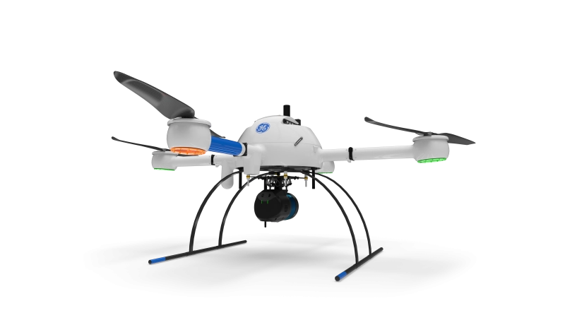
In addition, the GE industrial drone line adds an impressive new product to the existing Microdrones technology portfolio. The mdLiDAR1000LR system helps professionals collect data from a longer range, (especially helpful when working in steep or treacherous terrain) while covering more area per flight.
According to Microdrones CEO Vivien Heriard Dubreuil, “With an industrial focus, the GE industrial drone line is modular, expandable, upgradeable and simple to use in the production of high-quality geospatial data. This is a win for both GE and Microdrones, and most importantly our mutual customers.”

The interactive 3D visualization linked above was created with data collected by an mdLiDAR1000HR, in which an 1800 acre creek basin survey was completed in only three days.
GE Licensing Senior Managing Director Thomas Buccellato concluded: “The GE industrial drone line is a powerful extension and fit for the GE brand worldwide. We can provide field proven inspection, surveying and geomatics technology that complements our key industrial segments. This is just the beginning of something very promising as we work with Microdrones to scale this up and offer a very powerful and trusted drone surveying solution to our industrial customers worldwide.”
As part of its long-term commitment to Microdrones, GE has become an investor in the Microdrones parent company, mdGroup, and has committed to continue to invest in the near future. A GE representative has joined the mdGroup board of directors in an observer role. With their shared culture of customer focus, innovation and high-quality manufacturing, both companies will now work closely to make the GE industrial drone line a success.
A special presentation for geospatial, construction, mining and inspection professionals to explain the strategy behind the new relationship, answer frequently asked questions, and give an overview of the all new GE industrial drone line will take place Wednesday, July 14, 2021. Viewers can register to watch at either 9am CEST, 9am EDT or 6pm EDT at the following link: https://lp.microdrones.com/customer-announcement/
Visit the GE industrial drone line website here.
About Microdrones
Microdrones grew out of the collaboration between the German inventor of the world’s first commercial quadcopter and a determined surveying payload and software developer in North America. The result is a global aerial mapping technology company that delivers complete and reliable mapping systems specifically developed for the surveying, mining, construction, oil & gas and precision agriculture industries. Microdrones Integrated Systems are industrial tools addressing specific complex mapping challenges for professional customers, relying on a fully integrated geospatial workflow that enables cutting-edge software technology from Microdrones to transform raw data collected in the field by Microdrones survey equipment into valuable high-quality survey grade data. Microdrones is widely recognized for its LiDAR technology leadership.
Microdrones has engineering centers and manufacturing facilities in Germany, Canada, France, China and the United States, as well as a sales, support and distribution network spanning six continents. To learn more about Microdrones, visit www.microdrones.com