LETEL Gains the Aerial Advantage with Drone LiDAR Technology from GeoCue

See How LETEL Stands Out with Industry-Leading Surveying Services in New Episodes of the Drone Surveying Reality Series Down to Earth.
Buchanan, GA- GeoCue, announces the premiere of the latest episodes of its award-winning drone surveying reality series, Down to Earth. The new episodes highlight LETEL, a leader in civil engineering, drone technology, LiDAR, and construction services, and their innovative use of TrueView LiDAR technology and LP360 software to overcome complex surveying challenges in construction services and land development.
Before starting LETEL, John Downing began his journey in the construction industry digging ditches and getting his boots muddy. Determined to rise above, John embraced cutting-edge technology and invested in drones, a decision that transformed his career and led to the creation of LETEL.
Now, with over 20 years of experience, John has grown LETEL into a powerhouse in the construction and development industry. LETEL offers comprehensive services, from civil engineering to advanced drone technology, LiDAR, and construction solutions. The expert team of surveyors, engineers, LiDAR technicians, and pilots at LETEL can handle any project, big or small.
In these latest episodes of Down to Earth, watch as the LETEL team takes on a challenging 400-acre site with thick vegetation, steep elevation changes, and dense Georgia Pines. See how they use TrueView LiDAR technology to efficiently gather crucial data and quickly calculate volumetrics for their top client, Magnum Construction. All while the team skillfully navigates steep cliffs and steers clear of hazardous construction equipment, demonstrating the remarkable efficiency and precision of TrueView drone LiDAR.
See how the LETEL team leverages their Aerial Advantage on Down to Earth. Watch now!
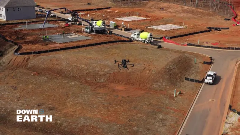
LETEL uses TrueView drone technology from GeoCue to scan a construction project.
“Down to Earth” is a documentary-style reality series that shows how real surveyors collect data and turn it into real deliverables, despite challenging conditions, hidden dangers, and inclement weather.
In the first episode, John and the LETEL team tackle a daunting 400-acre North Paulding site in Georgia, with significant elevation changes and dense pine forests. Using advanced TrueView LiDAR technology, they demonstrate how drone surveying can be completed in hours which would take traditional surveyors’ days or even months. Watch as they meticulously plan and execute their mission and coordinate their efforts seamlessly to deliver precise, high-quality data.
“The North Paulding Track presents quite a few challenges,” explained Downing. “There’s a 300-foot elevation change across a 400-acre fully wooded area. Georgia’s dense pine forests can interfere with our signal, making this a complicated job. However, I’m confident we’ll complete it within a day.”
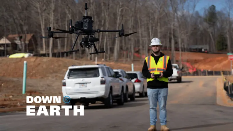
Nick King, UAS Pilot for LETEL, pilots the drone for a construction survey.
In the second episode, the LETEL team heads to Thompson Ridge to perform a critical dirt quantity check for Magnum Contracting. This episode showcases the incredible efficiency and accuracy of drone LiDAR technology in the construction industry. Despite the challenges posed by heavy machinery and active construction sites, the team gathers essential data swiftly and safely, enabling their clients to stay on top of project requirements and make informed decisions.
“As a customer of LETEL, we quickly realized the importance of their Drone LiDAR data,” said Brad Cox Founder and President Magnum Construction. “It has been a natural fit for our contracting and civil work, significantly enhancing our productivity and efficiency. The TrueView equipment is phenomenal, capturing incredible detail, even down to dozer track ridges in the topos. Their verification processes give us complete confidence in the accuracy of the data.”
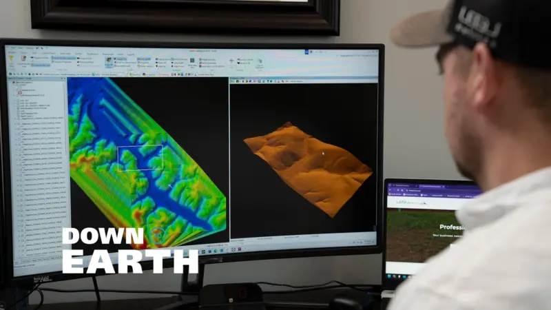
Christopher Bagley, data manager for LETEL, processes the LiDAR data in LP360 Drone software.
In the third and final episode, dive into the data processing phase with Christopher Bagley and the LETEL team as they transform raw LiDAR data into actionable insights using LP360 software. This episode highlights the meticulous steps taken to ensure accuracy and quality in their final deliverables. From classifying ground layers to creating detailed 3D models, see how the team leverages advanced tools to provide clients with unparalleled precision for new developments, even in heavily forested areas.
“We use LP360 because it’s the best tool available for ensuring accurate, reliable, high-quality data,” said Bagley. “It captures extensive details, including trees and elevation changes, and provides a comprehensive 3D view. The TrueView LiDAR performed flawlessly over the challenging terrain of the North Paulding site, giving us all the necessary data to create our deliverables.”
About LETEL
With over 20 years of experience in the construction and development industry, LETEL has established itself as a leader in civil engineering, drone technology, LiDAR, and construction services. Their expert team of surveyors, engineers, LiDAR technicians, and pilots is equipped to handle projects of any size, delivering unparalleled accuracy and efficiency.
LETEL goes beyond traditional engineering by offering professional business solutions crafted by industry veterans who understand the field firsthand. Their comprehensive services encompass construction, precision agriculture, and more. By utilizing cutting-edge drone technology, LETEL remains at the forefront of industry innovation, consistently providing top-tier results for their clients.
About GeoCue
GeoCue and Microdrones have joined together to bring geospatial experts the very best in drone surveying equipment, geospatial software, workflow, training and support for high accuracy LiDAR and drone mapping to help civil engineering and surveying professionals achieve successful data collection, processing, and management.
With its TrueView drone LiDAR/Imaging sensors, LP360 point cloud data processing software, and fully integrated systems from Microdrones, we are the leader in LiDAR mapping processing in North America able to meet customers where they are in terms of technology adoption, budget, and resources.
For more information, contact:
Bret Burghdurf
Marketing Director
GeoCue