Teeing Up an Abandoned Golf Course For Development with Drone Surveying
MP Design Group uses drone LiDAR technology to begin the redevelopment process.
Rome, NY- The greens are overgrown, the fairways are now part of the rough, and the tee boxes are extinct at an abandoned golf course in Biloxi, Mississippi. That’s why the team at MP Design Group was hired to create a feasibility study for residential development. To do this, they’ll use drone LiDAR technology to more efficiently create a topographic survey of the old golf course. However, bad weather is on the horizon and they also have to contend with Class D airspace due to the proximity of Keesler Air Force Base. See how they deal with these challenges and more in these new episodes of Down to Earth: LiDAR for the Course.
“Down to Earth” is a documentary-style reality series that shows how real surveyors collect data and turn it into real deliverables, despite challenging conditions, hidden dangers, and inclement weather.
In this 1st episode, Greg Thompson, PS, the VP of Field Services at MP Design Group, puts together the plan to scan the abandoned golf course with the construction inspector and drone pilot, Ryeley Jacobs. According to Thompson, “the mdLiDAR1000LR gives us the capabilities to penetrate tree canopies and wooded areas to collect more data for our ground topo and provide a better design surface for the engineers. We’re also able to provide the data much faster manner to our clients, allowing us to complete more jobs.
Completing more jobs is key to growing the business, as David Machado, the owner of MP Design Group, knows all too well. “The big difference between the LiDAR technology and conventional surveying is the time and manpower,” explains Machado. “It’s just totally changed the approach we’ve used in competing on surveying. It’s also changed the timeframe significantly reducing the turnaround times that we can give to our clients and provide them with the critical data that they are looking for.”
In the 2nd episode, Greg and Ryeley tee the drone up at the abandoned golf course and try to get the project completed in one days’ time, to afford them the opportunity to work on another project the following day. Jacobs is confident that the Microdrones technology will help them get both jobs completed much faster than conventional surveying methods. “The main thing with the Microdrones products is the time spent on these jobs. Time and budget are the most important things in this industry and the drone has helped tremendously.”
In the third and final episode of LiDAR for the Course, once the field work is complete, Thompson reviews and processes the data collected from the mdLiDAR1000LR, to create the final deliverables for his customer. He uses mdInfinity processing software to transform the raw survey data into the files needed to create a 3D point cloud of the ground surface. “The mdLiDAR1000LR was able to provide us with almost 62 million points on this short 22 minute flight,” said Thompson. “So, we have more than enough data available to create the topographic survey needed.”
PHOTO CAPTIONS:
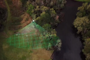
Down-To-Earth–LiDAR-for-the-Course-001: MP Design Group uses drone technology to scan an abandoned golf course
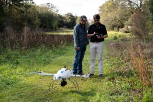
Down-To-Earth–LiDAR-for-the-Course-002: Greg Thompson, and Ryeley Jacobs prepare the mdLiDAR1000LR for the project
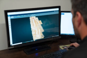
Down-To-Earth–LiDAR-for-the-Course-003: Greg Thompson reviews a 3D point cloud of the abandoned golf course
About MP Design Group
MP is a multi-disciplined Architecture, Engineering, and Land Surveying firm located in Biloxi, Mississippi, and has succeeded in creating its vision 14 years in the making and they stand proud as the only FULL-SERVICE design engineering firm on the Mississippi Gulf Coast.
MP Design Group has structured its business model around a philosophy to perform any service in-house, which in turn is seamless for their clients. MP provides a full-service A&E firm, employing civil, electrical, mechanical, and structural engineers, as well as surveying, and an in-house architecture under one roof.
About Microdrones
Microdrones is a German aerial mapping technology company that delivers industrial-grade survey equipment with a fully-integrated geospatial workflow that transforms data collected in the field into valuable high-quality survey-grade data. This transformation of collected data into actionable deliverables and their visualization is made possible thru the mdInfinity data processing platform.